
Back to Interventions Catalog
Case Study 8 (CS8)

Slope Reduction and Vegetation

Slope stabilization through vegetation management.

Pianton river (Venice)RuralRiverbank LandslidesFluvial FloodsBiodiversity LossErosion (riverbank)
Technical Dashboard
Context & Climate Hazards

Watercourse Management in the Venice Lagoon Basin

The water basin surrounding the Pianton River features an intricate drainage network. The broader area shows a high complexity in watercourse management.

Figure 1 shows the drainage basin of the Lagoon of Venice (Veneto region). The area corresponds to the area of competence of CBAR (Consorzio di Bonifica Acque Risorgive). It spans over more than 100,000 hectares (approximately 50% of the entire Lagoon of Venice drainage basin) and the total length of the river network is 2,350 km.

Managing and maintaining such a system is a complex task. Climate change is exacerbating the impacts of natural phenomena such as floods determined by extreme events and droughts. River bank landslides is an issue that can also be aggravated by climate change. Moreover, biodiversity loss is also a priority in the Veneto region. Flooding during extreme weather events can also be a concern and needs to be accounted for.
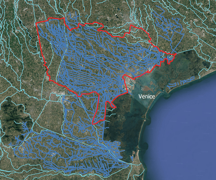
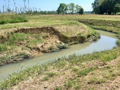
Figure 1: Drainage basin of the Lagoon of Venice (Veneto region). The area of competence of CBAR spans over more than 100,000 hectares and 2,350 km of river network.

Figure 1: Drainage basin of the Lagoon of Venice (Veneto region). The area of competence of CBAR spans over more than 100,000 hectares and 2,350 km of river network.

Riverbank Landslides
Main Hazard

Mainly caused by soil instability and water pressure. This is exasperated by extreme weather events.

Biodiversity Loss
Regional Priority

Caused by full vegetation clearance, habitat fragmentation, and hydroclimatic pressures.

Fluvial Floods
Extreme Events

During extreme weather events can also be a concern and needs to be accounted for.


NATALIE Solution

Natural River Restoration: NBS1 & NBS2

The Main Goal of the Case Study is to implement natural river restoration and maintenance techniques as an alternative to conventional ones. These are expected to also support positive ecological impacts besides enhancing an adaptive water management approach.

The main NBS solution employed for Riverbank Landslides is Slope reduction & vegetation. It also addresses Biodiversity Conservation.

Two NBS are assessed:

  • NBS1: It consists of maintaining a strip with uncut herbaceous vegetation at the base of the banks when operating the maintenance of watercourses.
  • NBS2: The main feature of the solution consists in modifying the shape of the banks along stretches that were subject to landslides. Therefore, the interventions consist firstly in the reduction of the bank's slope and secondly in vegetating the banks through transplanting of local shrubs and tree species.
Riparian area vegetation zones showing grass, brush, conifers, cottonwoods, birch, aspen, spruce, willows, dogwood, alder across uplands and stream sections.

Riparian area vegetation zones showing grass, brush, conifers, cottonwoods, birch, aspen, spruce, willows, dogwood, alder across uplands and stream sections.

Soil Stabilization
Natural Process

Mitigates Riverbank Landslides by providing the natural process of soil stabilization.

Water Attenuation
Natural Process

Mitigates Riverbank Landslides by providing the natural process of water attenuation.

Biodiversity Conservation
Natural Process

Mitigates Biodiversity Loss by providing the natural process of biodiversity conservation.


Sustainable Maintenance

Sustainable Approach to River Maintenance

Managing and maintaining a river network of 2,350 km spanning over more than 100,000 hectares is a complex task. Climate change is exacerbating the impacts of natural phenomena such as floods determined by extreme events and droughts.

Maintenance is therefore a "must", but there's an important need to operate adopting a sustainable approach, in order to get rid of vicious circles.

The Main Goal of the Case Study is to implement natural river restoration and maintenance techniques as an alternative to conventional ones. These are expected to also support positive ecological impacts besides enhancing an adaptive water management approach.

Maintenance is therefore a "must", but there's an important need to operate adopting a sustainable approach, in order to get rid of vicious circles.

Consorzio di Bonifica Acque Risorgive (CBAR)


Monitoring & Telemetry

Hydraulic Conditions & Biodiversity Monitoring

The activity consists of two types of monitoring regarding hydraulic conditions and biodiversity:

  • Hydraulic conditions: installation of continuous level sensors in two watercourses (Pianton, Vernise); execution of flow measures campaigns.
  • Biodiversity: birds, lepidoptera, odonates.
  • Other activity: monitoring the presence of nutria (coypu) in order to assess how it is affected by the NBS.
  • Meteorological data: also collected from Mogliano Veneto Station.
Hydraulic Conditions
Sensors
Pianton & Vernise

Continuous level sensors in two watercourses (Pianton, Vernise) and flow measures campaigns.

Biodiversity Monitoring
Ecology
3 Target Taxa

Monitoring of birds (abundance across four Pianton survey sites), lepidoptera, and odonates.

Vegetation Cover
Transects
40.7% Helophytes

Helophytes cover 40.7% along NBS transect vs 13.3% in complete cut (CC) control transect.

Meteorological Data
Meteo Station
Mogliano Veneto

Collection of precipitation (mm), wind speed (m/s), and temperature (°C) data.

Explore the Live Technical Dashboard

Access real-time water levels (AR042–AR045), Mogliano Veneto meteorological timeseries, HEC-RAS 1D flood simulation plots, and multi-criteria radar impact indicators.

Go to Technical Dashboard

Model Simulations

HEC-RAS 1D Hydraulic Modeling

The effects of "Slope reduction & vegetation" are simulated through a HEC-RAS, 1D Hydraulic model. The NBS is accounted for through modifications in Geometry and Roughness.

Modeling: HEC-RAS 1D modelling of two rivers (Pianton, Vernise). Scenarios evaluate water levels under RCP 4.5 for the 2036–2065 timerange (comparing NO NBS with WITH NBS) and cross-section velocity plots.

Hydraulic Model
Model
HEC-RAS 1D

HEC-RAS 1D modelling of two rivers (Pianton, Vernise).

Geometry
NBS Feature
Slope Reduction

The NBS is accounted for through modifications in Geometry.

Roughness
NBS Feature
Manning's n

The NBS is accounted for through modifications in Roughness.

Climate Scenario
Scenario
RCP 4.5 (2036-2065)

Simulating water level differences: NO NBS vs WITH NBS.


Performance & Resilience

Hazard Reduction & Resilience Assessment (T3.3)

Performance assessment of the solution tracks indicators across multiple categories:

  • Riverbank Landslides-reduction indicators: Shear stress, Potential landslide area.
  • Flood indicators: Flood depth/level.
  • Biodiversity loss-reduction indicators: Diversity (Shannon Index), Dominance (Simpson Index), Species richness for each taxon, Population size (abundance) of target Taxa, Coverage and proportion of hydrophile vegetation.
  • Nutria (Coypu) Monitoring: Abundance of Coypu burrows along sample transects (0.7, 0.5, 0.9 burrows / 100 m).

Resilience Assessment: Resilience assessment framework developed under Task 3.3 to evaluate long-term adaptive capacity and climate resilience (Status: To be defined).

Landslide Reduction
Hazard Indicator
Shear Stress

Shear stress and potential landslide area indicators tracking bank stability.

Biodiversity Indices
Ecology Indicator
Shannon & Simpson

Diversity, dominance, species richness, and target taxa population abundance.

Coypu Burrows
Invasive Species
0.5–0.9 / 100m

Monitoring the presence of nutria (coypu) to assess how it is affected by the NBS.

Resilience Assessment
T3.3
Task 3.3

Resilience assessment framework developed under Task 3.3 (Status: To be defined).